The oil & gas mecca that is Virginia, you'd be surprised to know that they were unaware of this whole "API" thing before October of 2014. At that time, Virginia decided to abandon its BFF, Indiana, and adopt the API/UWI numbering system for oil & gas wells. You could forgive them for their late arrival to the party, the state of Virginia maxed out at 750 permits for the entire year of 2007. For reference, TX processed more than 1,000 permits per month in 2023.
Still, not using an API number is unfathomable in the US oil & gas industry, and back on that cool fall day in 2014, Rick Cooper (then Director of the Division of Gas and Oil (DGO) in Virginia) changed that. He would publish a memo explaining that Virginia would adopt the UWI/API spec in accordance with the PPDM standard. He rightly believed that this consistency would help just about everyone involved in the Virginia oil & gas industry.
Since that time, Virginia has processed a grand total of 1,158 permits. Hey, at least they have API numbers...
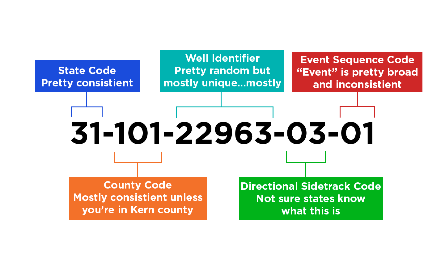
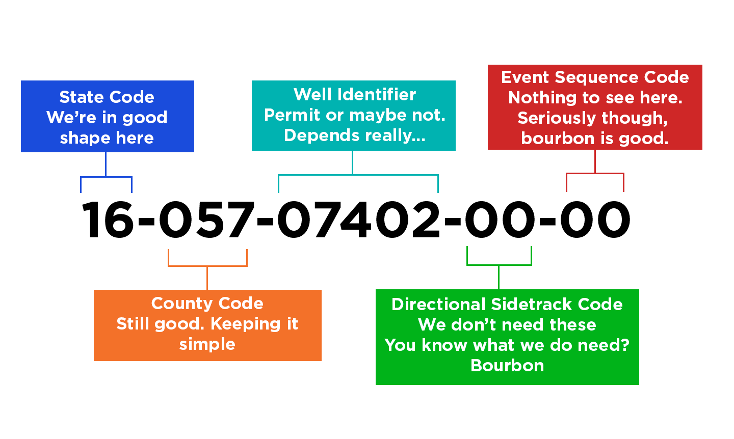
Virginia uses a 12-digit number that consists of four semantic parts: the state code, county code, well code, and wellbore code as follows:
- The first two digits are the state code, which is 45 for the Commonwealth of Virginia.
- The next three digits are the county code. For example, 027 is the county code for Buchanan county. A complete list of county codes is available at wellidentification.org/usa.
- The following five digits are a unique identifier for the well based on the DGO File Number. The file number was selected in lieu of the permit number because the file number does not change and is more commonly used to find information on the DGO Data Information System.
The DGO file number consists of a two-letter county abbreviation followed by a four-digit number. In general, the five-digit well identifier in the UWI/API well number is a zero followed by the four-digit number from the file number. However, a different format was used for some of the early file numbers; they consisted of the letter A followed by a two-digit number and then a two-letter county abbreviation. For these file numbers, to avoid duplication, the five-digit number begins with 500 and then the two-digit number from the file number. Examples are shown at the end of this document for clarification.
- The last two digits are the wellbore identifier. For wells with a single wellbore, these digits will be 00. For wells with two or more laterals branching from a primary wellbore at the surface, each wellbore will be identified by the permit applicant on a map and/or cross-section and then listed in the Wellbore Identification section of the Eforms permit application. The Eforms system will automatically assign a sequential two-digit number to each wellbore listed in the application,
In addition, a new wellbore identifier is assigned to wellbores to deepen, bypass, or deviate a well. The wellbore used to deepen, bypass, or deviate a well must be identified on a map and/or cross-section and listed in the Wellbore Identification section in the permit modification application.
- Examples:
Buchanan County Well:
File Number: BU-432 UWI/API Number: 450270432100
State: 45 County: 027 Well: 04321 Wellbore: 00
Lee County Well:
File Number: A01LE UWI/API Number: 450505000100
State: 45 County: 050 Well: 50001 Wellbore: 00
Buchanan County Well with Two Laterals:
File Number: BU-4816
State: 45 County: 027
Center wellbore (original) UWI/API Number: 450270481600
East wellbore (lateral #1) UWI/API Number: 450270481601
West wellbore (lateral #2) UWI/API Number: 450270481602
 Pam Koscinski


v2.png)
%20NUMBERS-1.jpg)