This blog is the latest in our series all about our favorite well identifier, the API number. We talk to a lot of users and we find that there is a lot of misunderstandings about what exactly the API number is and is not. This series is aimed at trying to help clear up some of those misunderstandings and give insight into how we handle the API issues and inconsistencies here at WellDatabase.
If you missed it, check out the other blogs in the series
For oil and gas related wells drilled in Alaska’s state lands and waters, the AOGCC assigns a standard 14-digit number as recommended by API Bulletin D12A, dated January 1979, and titled “The API Well Number and Standard State and County Numeric Codes Including Offshore Waters.” A more recent set of numbering standards has been issued by the PPDM Association after ownership of the standard was transferred by the API to them but for uniformity, the AOGCC conforms to the 1979 API bulletin, as discussed below.
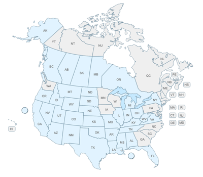
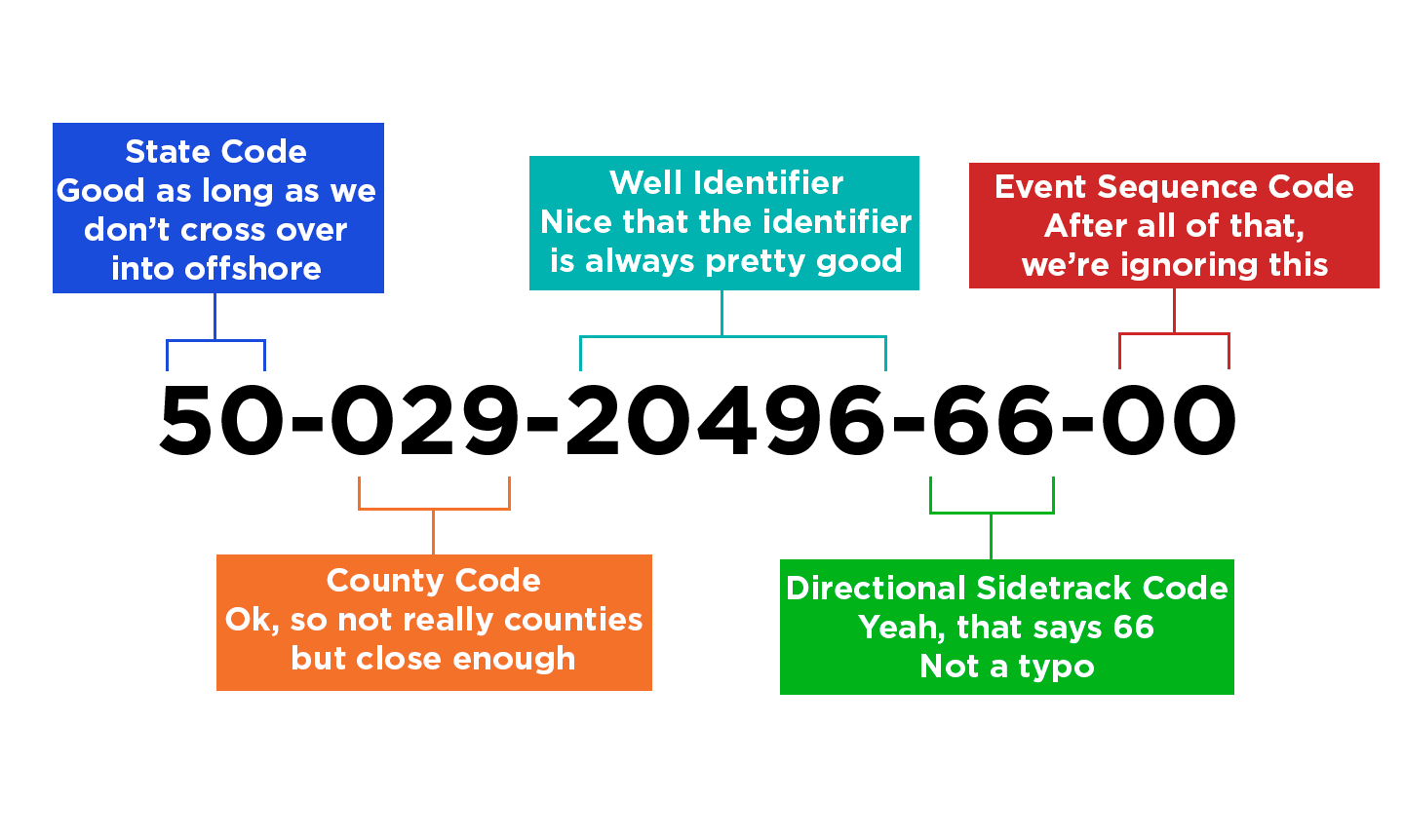
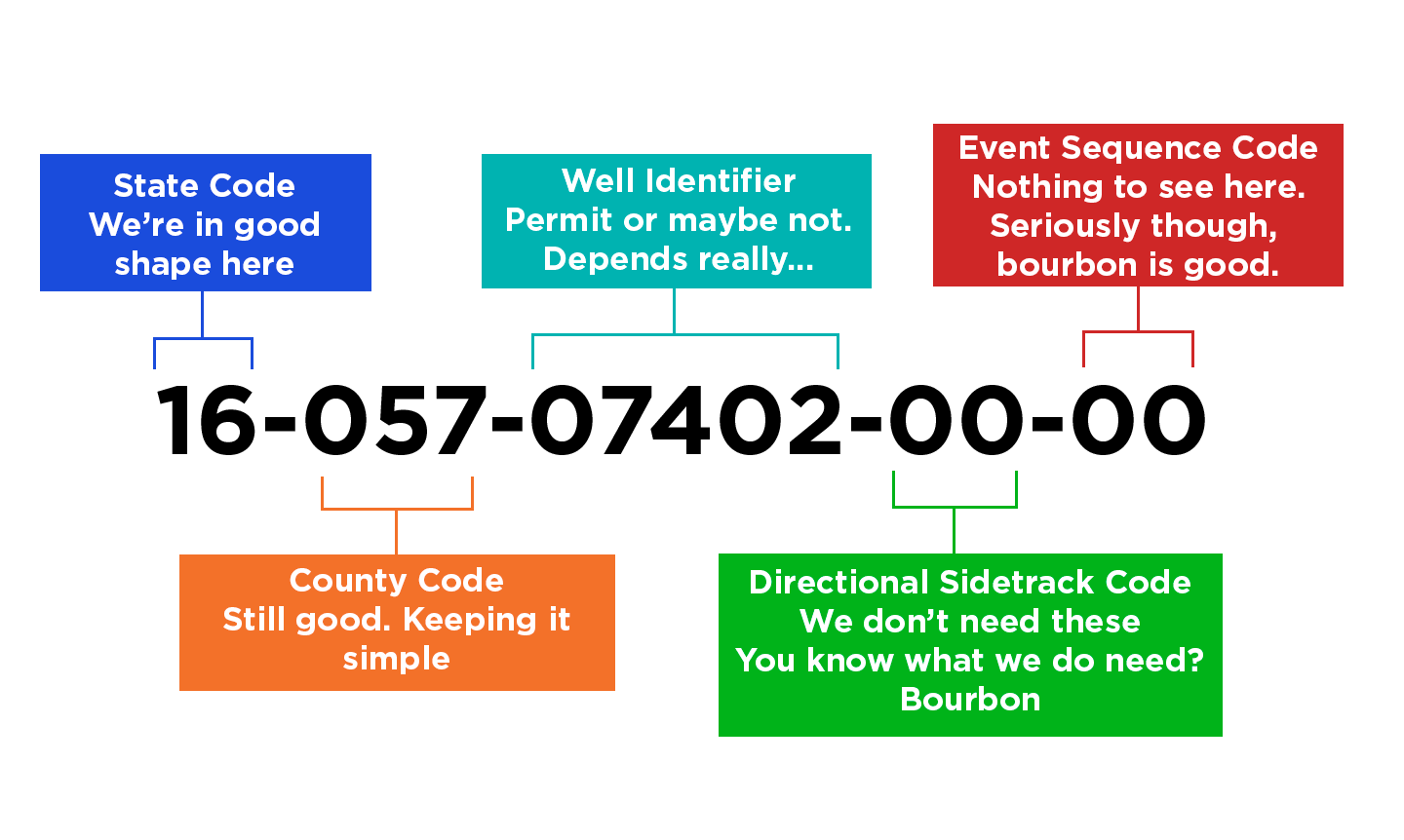
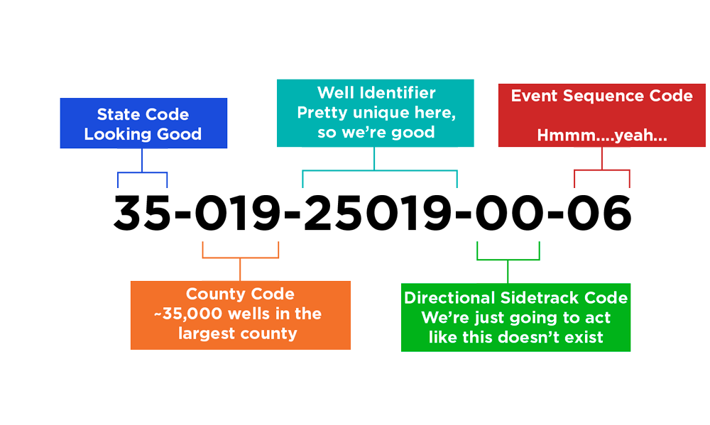
The AOGCC assigns Unique Well Identifiers (API) numbers based on the surface location of the well (as explained further, below). For example, the UWI (API) number for North Slope production well Kuparuk River Unit 1E-08 (Kuparuk River Unit, Drill Site 1E, Slot Number 8) is 50-029-20946-00-00. This number conforms to the standard UWI (API) numbering pattern:
- 50 is the state code.
- 029 is the “county” code for Beechey Point USGS 1:250,000 quadrangle (In Alaska, there are extremely large boroughs rather than counties. The North Slope Borough alone is about the size of California so instead they use a pseudo-county code based on the USGS quadrangle numbers in place of the county code. For offshore locations, the AOGCC uses a number 6 for the 3rd digit of the API, so an offshore well that lies within Beechey Point quadrangle would have 629 as the pseudo-county code).
- 20496 is a 5-digit well code that is assigned in sequence as permit to drill applications for that particular quadrangle arrive at the AOGCC.
- The 11th and 12th-digits are used for the directional code as follows:
- The digits 00 are used for new wells.
- The digits 01-39 are reserved for redrilled wellbores (the original productive interval in the parent well is isolated, and the well is redrilled to a separate downhole objective; some operators incorrectly refer to these as “sidetracks”
- 40-59 are reserved for those (currently) rare instances where there are more than 10 well branches and spokes drilled from pre-existing wells and well branches (e., the 10th lateral or spoke drilled will have a “69” as the 11th and 12th API Number digits, and the 11th lateral drilled will have “40” as the 11th and 12th API Number digits.) This is currently exceedingly rare but will become more prevalent in the future (e.g., BlueCrest’s Hansen “fishbone” laterals on the Kenai Peninsula).
- 60-69 are reserved for well branches and “spokes”, which are drilled from pre-existing well branches – more on this later; for a well or redrill with subsequently drilled branches, these 60-series code numbers are issued sequentially in the order that the Permit to Drill applications are received by the AOGCC).
- 70-79 are reserved for plugged-back wellbores that are pilot holes, junked wellbores, or inadvertently drilled wellbore segments.
- 80-89 are reserved for internal use by operating companies; and
- 90-99 are used for re-entries of plugged back wells).
- The 13th and 14th digits, the set of double-zeroes is the “completion code.” These digits are currently not used by Alaska and they are always set to 00. Many operators use only a 12-digit UWI (API) number in their internal databases. However, AOGCC’s databases are built on 14-digit API numbers, so all forms submitted to the AOGCC must specify a 14-digit UWI (API) numbers.
Note: AOGCC does not consider the terms “lateral” and “horizontal” as synonymous. As applied to wells, the adjective “horizontal” denotes any wellbore that reaches a maximum angle of inclination (from vertical) of 80 or more degrees. The term “lateral” denotes any well branch that is opened to the oil or gas pool at the same time the primary well is still open to that same pool. So, one can have a lateral well branch that is not also horizontal, and vice versa. Also, since the AOGCC generally doesn’t have a means of allocating production between the primary well and open lateral well branches, the combined production from a wellbore and its lateral well branches is reported only against the primary well.
In AOGCC’s database, one also may occasionally run across API numbers that have 11th and 12th digits set to 95. In the distant past, if a Permit to Drill was not used (it expired or was cancelled by the operator) often the 11th and 12th digits of the API number were then changed to the 95 suffix and the original UWI (API) number may have been used again. This was before their current “RBDMS” (“Risk-Based Data Management System”) database was brought on line in 2002. This RBDMS database requires a one-to-one correspondence between assigned Permit to Drill and UWI (API) numbers, so now if a permit expires, is cancelled, or is not approved by the AOGCC, the file is closed and the corresponding Permit to Drill and API numbers are never used again.
Occasionally odd things happen, and unusual API numbers are required. For example, say the ACME Company wants to redrill the Smith No. 1 well to a new bottom-hole location in a separate fault block. This redrill will be named Smith No. 1A. ACME Company submits a new Permit to Drill application for Smith No. 1A. The AOGCC assigns that application a new, unique Permit to Drill Number and an API Number that ends in -01-00 since it is the first redrill of the Smith No. 1 well (the API Number will be, for example, 50-029-12345-01-00, per the procedures discussed above). The AOGCC’s Permits to Drill are valid for two calendar years. Shortly thereafter, ACME Company runs into financial trouble, and doesn’t have sufficient funds to drill the Smith No. 1A redrill. ACME Company lets the Permit to Drill expire. Remember, the AOGCC’s database requires a one-to-one correspondence between the Permit to Drill Number and the UWI (API) Number. Accordingly, after the Permit to Drill expires, the file for the Smith No. 1A well is closed for both the AOGCC’s paper records and the RBDMS database. The Permit to Drill Number and API Number 50-029-12345-01-00 have already been used for this closed file, so they are never used again.
Three years later, ACME Company resolves their financial difficulties and can now afford to redrill the Smith No. 1 well. They submit a new Permit to Drill application for the Smith No. 1A redrill. The AOGCC assigns this new application a new, unique Permit to Drill Number. Since the original API number 50-029-12345-01-00 is no longer available, the new API Number that the AOGCC must assign to the Smith No. 1A redrill is 50-029-12345-02-00. Sometimes you will run across these instances in the AOGCC’s database (an “A” suffix on the well number that suggests this wellbore will be the initial redrill and a corresponding UWI (API) Number that ends in -02-00, which suggests this wellbore will be the second redrill). So, if you have questions about a particular well, they recommend that you review the scanned images of the AOGCC’s history file for that well, which are available using the WebLink application that can be found on AOGCC’s home page at https://www.commerce.alaska.gov/web/aogcc/Home.aspx. (Hover your cursor over the key word “Data” and select WebLink from the drop-down menu.)
Additional details, which are probably more than you want to know, but are helpful to understand.
In Alaska, API numbers are assigned based on the surface location of the well. For example, a well drilled directionally from an onshore surface location along Alaska’s north coastline within the Beechey Point quadrangle to an offshore location within this same quadrangle would be assigned an API number beginning with 50-029-XXXXX-XX-XX. In contrast, a vertical well drilled from a temporary ice island just offshore of that same onshore drill site would be assigned an API number beginning with 50-629-XXXXX-XX-XX. The reasoning is that at some later time, the offshore bottom hole location of the directionally drilled well could be plugged and abandoned and the well could be re-drilled back to an onshore bottom hole location without requiring a change to the pseudo-county code in the UWI (API number). If the UWI (API) number had been assigned to the directionally drilled well based on the offshore bottom hole location (50-629-XXXXX-XX-XX), redrilling that well to a new, onshore bottom hole location would require changing the UWI (API) number to 50-029-XXXXX-XX-XX. That would be confusing.
AOGCC issues a separate permit to drill for every wellbore because they wish to track exactly where each wellbore is located (to avoid collisions) and what sort of pipe, cement and completion jewelry are in the wellbore. Several years back (about 2005), operators there in Alaska began to drill more complex wells. For example, a well named Kuparuk River Unit 1E-08 (50-029-20496-00-00) was plugged and abandoned, a whipstock was set, and the well was redrilled to a new bottom hole location. This new well was named Kuparuk River Unit 1E-08A and its API number became 50-029-20496-01-00. The next year, the operator decided to leave this redrill open to the formation and to add two horizontal, lateral wellbores that both branch from the redrill well 1E-08A. These horizontal lateral wellbores are named Kuparuk River Unit 1E-08AL1 and Kuparuk River Unit 1E-08AL2, respectively. From these two lateral wellbores, the operator subsequently decided to drill three additional wellbores, which AOGCC terms “spokes.” The resulting names and API numbers below are presented in the order these wellbores were permitted and drilled.
Kuparuk River Unit 1E-08 50-029-20496-00-00
Plugged and abandoned original wellbore
Kuparuk River Unit 1E-08A 50-029-20496-01-00
First redrill of original redrilled wellbore to a new downhole location, produced, then left open to the formation to continue production when laterals are subsequently drilled
Kuparuk River Unit 1E-08AL1 50-029-20496-60-00
First lateral wellbore drilled from the first redrill of the original wellbore to the same reservoir. Combined production from 1E-08A and 1E-08AL1 is reported against 1E-08A.
Kuparuk River Unit 1E-08AL1-01 50-029-20496-61-00
First spoke wellbore drilled from the first lateral wellbore to the same reservoir. Combined production from 1E-08A, 1E-08AL1 and 1E-08AL1-01 is reported against 1E-08A.
Kuparuk River Unit 1E-08AL1-02 50-029-20496-62-00
Second spoke drilled from the first lateral wellbore to the same reservoir (See the attached schematic diagram, below, which summarizes 1E-08 and subsequent drilling to this point.)
Kuparuk River Unit 1E-08AL2 50-029-20496-63-00
Second lateral drilled from the first redrill of the original wellbore to the same reservoir
Kuparuk River Unit 1E-08AL2-01 50-029-20496-64-00
First spoke drilled from the second lateral wellbore to the same reservoir
Kuparuk River Unit 1E-08AL1-03 50-029-20496-65-00
Third spoke drilled from the first lateral wellbore to the same reservoir (this may be slightly confusing, but this third spoke from the first lateral was drilled after the first spoke from the second lateral; note again that the 60-series directional code numbers are issued sequentially in the order the Permit to Drill applications are received by the AOGCC),
Kuparuk River Unit 1E-08B 50-029-20496-02-00
Second redrill of original wellbore 1E-08. The productive portion of 1E-08A is plugged and abandoned; redrill 1E-08B is drilled by setting whipstock, kicking off, and exiting the casing within the upper portion of 1E-08A. All subsequent production is reported against 1E-08B.
Kuparuk River Unit 1E-08BL1 50-029-20496-66-00
First lateral wellbore drilled from the second redrill of the original wellbore to the same reservoir
Kuparuk River Unit 1E-08BL1-01 50-029-20496-67-00
First spoke wellbore drilled from the first lateral wellbore to the same reservoir
This particular well currently has the main wellbore (1E-08A) and six subsidiary horizontal wellbores are all open to the reservoir and contributing to production. Based on this well naming scheme, one can immediately get a sense of which spoke wellbores branch from which lateral wellbores. This tracking system is not ideal, but it is workable. In the future, AOGCC will likely use the term “spikes” for wellbores that branch from spokes, and they would track the resulting wellbores by naming the first spike that branches from the first spoke that branches from the first lateral drilled from the first redrill as Kuparuk River Unit 1E-08AL1-01-01. And so on… Once they run out of 60-series numbers for laterals, spokes and spikes, they will wrap back to the 40-series numbers because the 70-, 80-, and 90-series numbers are currently in use. Again, a system that is not ideal, but is workable.
 Pam Koscinski